Surveying may not sound like the most glamorous profession—after all, no one’s making reality TV shows about theodolites and GPS receivers. But behind every perfectly constructed bridge, accurately mapped country, or neatly divided parcel of land lies the work of skilled surveyors. At the heart of surveying are two fundamental methods: plane surveying and geodetic surveying.
These techniques might seem interchangeable to the uninitiated, but their applications are as distinct as chalk and cheese. Understanding the differences between the two is critical, whether you’re an engineering student, a professional surveyor, or someone curious about how we measure and map our world.

Surveying is, quite simply, the science (and art) of measuring distances, angles, and positions on the Earth’s surface. It’s been around since ancient times—think Egyptians aligning the Great Pyramids or Romans laying out roads that have withstood millennia.
The basic goal of surveying is to determine the relative positions of points on the Earth, and it’s the foundation of engineering, construction, and mapping. Surveying ensures that a highway aligns correctly with a bridge, that skyscrapers are built plumb, and that property boundaries don’t end in neighbourly disputes (or lawsuits).
Modern surveying combines tried-and-true manual techniques with cutting-edge technologies like satellites, drones, and geographic information systems (GIS). But to choose the right surveying method for a project, one must first understand the core methods: plane surveying and geodetic surveying.

What Is Plane Surveying?
Definition of Plane Surveying
Imagine you’re building a small shed in your backyard. You’re not particularly concerned about the curvature of the Earth or the precise shape of your property relative to the equator. You just need to measure your plot of land accurately and ensure the shed is level. That’s where plane surveying comes in.
Plane surveying assumes that the Earth is a flat surface. This simplification works for smaller areas—think farms, neighborhoods, or small towns—where the curvature of the Earth is negligible. For projects of this scale, ignoring the Earth’s spherical shape doesn’t lead to any significant errors.
Characteristics of Plane Surveying
Plane surveying is all about simplicity and practicality. Here are its key traits:
- Flat Earth Approximation: Plane surveying treats the Earth as a flat plane, which simplifies calculations.
- Small-Scale Focus: Best suited for areas under 250 square kilometers, where curvature effects are minimal.
- Straightforward Techniques: Involves simpler mathematical formulas and methods compared to geodetic surveying.
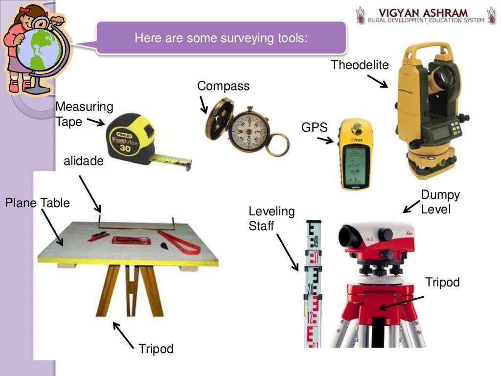
- Accessible Tools: Traditional tools like chains, tapes, and levels are often used alongside more modern equipment like total stations.
Applications of Plane Surveying
Plane surveying shines in scenarios where high precision across large areas isn’t required. Here’s where it’s typically used:
- Construction Projects: Whether it’s laying the foundation for a house or planning roads, plane surveying ensures accurate measurements.
- Land Subdivision: Surveyors rely on plane surveying to divide land into plots for sale or development.
- Agriculture: Farmers use plane surveying to measure fields for irrigation or crop planting.
For instance, when planning the layout of a new residential development, surveyors use plane surveying to establish lot boundaries and road alignments. The simplicity and cost-effectiveness of this method make it ideal for such projects.
Advantages of Plane Surveying
Why choose plane surveying? Here are a few reasons:
- Cost-Effectiveness: Simpler techniques and tools mean lower expenses.
- Ease of Use: Requires less specialized training and equipment compared to geodetic surveying.
- Faster Results: Since calculations are straightforward, results are obtained more quickly.
Tools Used in Plane Surveying
Traditional and modern tools make plane surveying efficient and accurate. These include:
- Measuring Chains and Tapes: For measuring distances the old-school way.
- Theodolites: For determining angles and elevation differences.
- Total Stations: A modern all-in-one tool combining angle measurement, distance measurement, and data recording.
- Levels and Plumb Bobs: To ensure structures are horizontal or vertical.
Fun fact: The oldest recorded use of surveying tools dates back to ancient Egypt, where surveyors used a tool called a “plummet” to ensure that the Pyramids of Giza were perfectly aligned. Talk about precision!
Plane surveying might be basic, but it’s the backbone of countless small-scale projects. It’s like the dependable old pickup truck of surveying—simple, rugged, and gets the job done.

What Is Geodetic Surveying?
Definition of Geodetic Surveying
Now, imagine you’re tasked with mapping an entire country or planning a massive pipeline that spans multiple states. Suddenly, the Earth’s curvature becomes impossible to ignore. Geodetic surveying steps in when large-scale accuracy is essential.
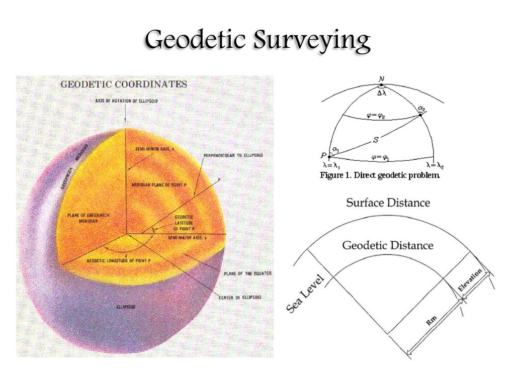
Geodetic surveying considers the Earth as a spherical (or more accurately, ellipsoidal) shape. This method involves accounting for the Earth’s curvature to ensure precise measurements over vast distances. Unlike plane surveying, geodetic surveying aligns with a global coordinate system, making it the go-to technique for mapping large areas and infrastructure projects.
Characteristics of Geodetic Surveying
Geodetic surveying stands out because of its complexity and accuracy. Key characteristics include:
- Curvature of the Earth: Measurements incorporate the Earth’s ellipsoidal shape, correcting for its curve over long distances.
- Global Reference Systems: Uses established coordinate systems like latitude, longitude, and altitude.
- Advanced Tools and Techniques: Employs satellite systems, GPS, and geodetic models to achieve high precision.
- High-Precision Results: Accounts for even minute variations in the Earth’s surface, such as tectonic shifts.
This level of precision makes geodetic surveying indispensable for large-scale, high-stakes projects.
Applications of Geodetic Surveying
Geodetic surveying isn’t just for ambitious government projects or global infrastructure. It’s also critical for the modern digital world. Here are some key applications:
- Mapping Large Areas: Used to create accurate maps of countries, continents, and even the entire Earth.
- Navigation Systems: Global Positioning Systems (GPS) rely on geodetic principles for pinpoint accuracy.
- Infrastructure Development: Essential for planning highways, bridges, pipelines, and other large-scale projects.
- Earth Monitoring: Tracks tectonic movements, rising sea levels, and other geological phenomena.
For example, the Panama Canal expansion project relied heavily on geodetic surveying to ensure that new locks and waterways were aligned precisely with existing structures.
Advantages of Geodetic Surveying
While geodetic surveying requires more time and resources, its benefits make it worth the effort for large-scale projects:
- Exceptional Accuracy: Capable of measuring distances and angles with minute precision over vast areas.
- Global Compatibility: Results align with worldwide coordinate systems, making data universally usable.
- Critical for Technology: Satellite navigation, space exploration, and geospatial mapping all depend on geodetic principles.
Tools Used in Geodetic Surveying
Because of its complexity, geodetic surveying relies on advanced technology. Common tools and methods include:
- Satellite Systems: GPS, GLONASS, and other satellite networks are the backbone of geodetic surveying.
- Geodetic Models: Use ellipsoidal and geoid models to represent the Earth’s shape accurately.
- High-Precision Instruments: Tools like gravimeters and electronic distance meters (EDMs) help measure variations in gravity and distances with precision.
Geodetic surveying may sound like something out of a science fiction movie, but it’s a cornerstone of modern engineering and technology. It’s the rocket scientist cousin to plane surveying—complicated, but undeniably impressive.

Key Differences Between Plane Surveying and Geodetic Surveying
At first glance, plane surveying and geodetic surveying might seem like they serve the same purpose—measuring distances, angles, and positions on Earth. However, their differences become clear when you consider scale, accuracy, and complexity. Let’s break down the distinctions between these two methods.
Assumptions About Earth’s Shape
- Plane Surveying: Assumes that the Earth is a flat surface. This assumption simplifies calculations but is only accurate for small areas where the Earth’s curvature is negligible.
- Geodetic Surveying: Recognizes the Earth’s ellipsoidal (slightly flattened sphere) shape, incorporating curvature into measurements. This ensures accuracy across larger distances.
For example, if you’re surveying a park, ignoring the Earth’s curvature won’t lead to significant errors. But if you’re mapping a transcontinental railroad, those small inaccuracies can snowball into major problems.
Scale and Scope
- Plane Surveying: Typically used for projects covering smaller areas, such as construction sites, neighborhoods, or farms. The scale is local, not regional or global.
- Geodetic Surveying: Focused on large-scale projects, such as mapping entire countries, monitoring tectonic movements, or planning international infrastructure.
| Aspect | Plane Surveying | Geodetic Surveying |
|---|---|---|
| Typical Area Size | Less than 250 sq. km | Hundreds to thousands of sq. km |
| Geographic Focus | Local | Regional, national, or global |
Techniques and Tools
- Plane Surveying: Uses simpler tools like chains, tapes, and theodolites. These tools are sufficient for small-scale measurements and straightforward calculations.
- Geodetic Surveying: Leverages advanced technologies like satellites, GPS, and electronic distance meters. It also relies on geodetic models to account for curvature and irregularities in Earth’s surface.
A practical comparison would be using a ruler versus a laser scanner. While both measure distances, their precision and scope are worlds apart.
Accuracy and Complexity
- Plane Surveying: Simpler and less complex, but its accuracy diminishes as the surveyed area increases. Errors grow exponentially if Earth’s curvature isn’t considered.
- Geodetic Surveying: Far more complex, involving intricate calculations and models, but it provides exceptional accuracy, even over vast distances.
For instance, consider a boundary dispute over 100 kilometers of land. Plane surveying might result in discrepancies of several meters, while geodetic surveying would pinpoint positions with millimeter-level accuracy.
Cost Considerations
- Plane Surveying: Cost-effective for smaller projects due to simpler tools, fewer resources, and less time required.
- Geodetic Surveying: More expensive because it involves advanced equipment, global positioning systems, and specialized expertise.
Key Insight: Choosing the right method isn’t about one being “better” than the other. It’s about aligning the method with the project’s size, budget, and precision needs.

When to Use Plane Surveying vs. Geodetic Surveying
Choosing between plane surveying and geodetic surveying depends on the nature and scope of your project. Here’s a guide to help you make the right decision.
Factors to Consider
- Project Size
- Small Projects: Plane surveying is ideal for small areas, like property lines, residential developments, or localized construction projects.
- Large Projects: Geodetic surveying is necessary for projects spanning large areas, like state highways, national boundaries, or regional mapping.
- Accuracy Requirements
- Moderate Accuracy: If slight deviations won’t significantly impact the project (e.g., a local road), plane surveying suffices.
- High Precision: When accuracy is paramount, such as in satellite positioning or large infrastructure, geodetic surveying is indispensable.
- Budget Constraints
- Tight Budgets: Plane surveying is generally more affordable due to simpler tools and faster completion times.
- Larger Budgets: Geodetic surveying demands more resources but delivers exceptional precision and global compatibility.
Real-World Examples
- Plane Surveying in Action:
A suburban housing development required precise plotting of roads and lot boundaries. Surveyors used plane surveying because the area was small, and the flat-Earth assumption introduced no noticeable errors. - Geodetic Surveying in Action:
During the construction of the transcontinental railway, engineers relied on geodetic surveying to align tracks across thousands of kilometers. Accounting for the Earth’s curvature ensured the tracks met perfectly.
Decision-Making Table
Here’s a quick table to summarize when to use each method:
| Criteria | Plane Surveying | Geodetic Surveying |
|---|---|---|
| Area Size | Small (e.g., <250 sq. km) | Large (e.g., >250 sq. km) |
| Accuracy Required | Moderate | High |
| Project Examples | Roads, small buildings, subdivisions | National highways, pipelines, mapping |
| Cost | Low | High |
| Tools | Chains, levels, theodolites | GPS, satellites, electronic distance meters |
Pro Tip
When in doubt, ask yourself: “How much does accuracy matter?” If the answer is “a lot” (or you’re working with a project visible from space), go with geodetic surveying. For everything else, plane surveying is likely sufficient.