Have you ever wondered how maps are so accurate that they can guide you to the nearest coffee shop, pinpoint the location of a hidden hiking trail, or even help airplanes navigate the skies? That magic lies in the synergy between geodetics and GIS (Geographic Information Systems). Without geodetics, GIS would be a chaotic puzzle, with pieces scattered all over the place—accurate but impossible to align.
Geodetic in GIS refers to the principles and methods that help us define the Earth’s shape, size, and gravity, ensuring that all the spatial data aligns correctly. This field ensures that mapping and spatial data systems are grounded in precision and reliability. Think of it as the GPS signal for your favorite map app—it’s not flashy, but you’d be lost without it.

Understanding Geodetics: A Foundational Concept
To understand geodetic in GIS, we first need to tackle the concept of geodetics itself. At its core, geodetics (or geodesy) is the science that measures and maps the Earth’s shape, size, gravitational field, and orientation in space. It’s like giving the Earth its own ID card—a detailed description of its physical characteristics. Now let’s break it down step by step.
What Does “Geodetic” Mean?
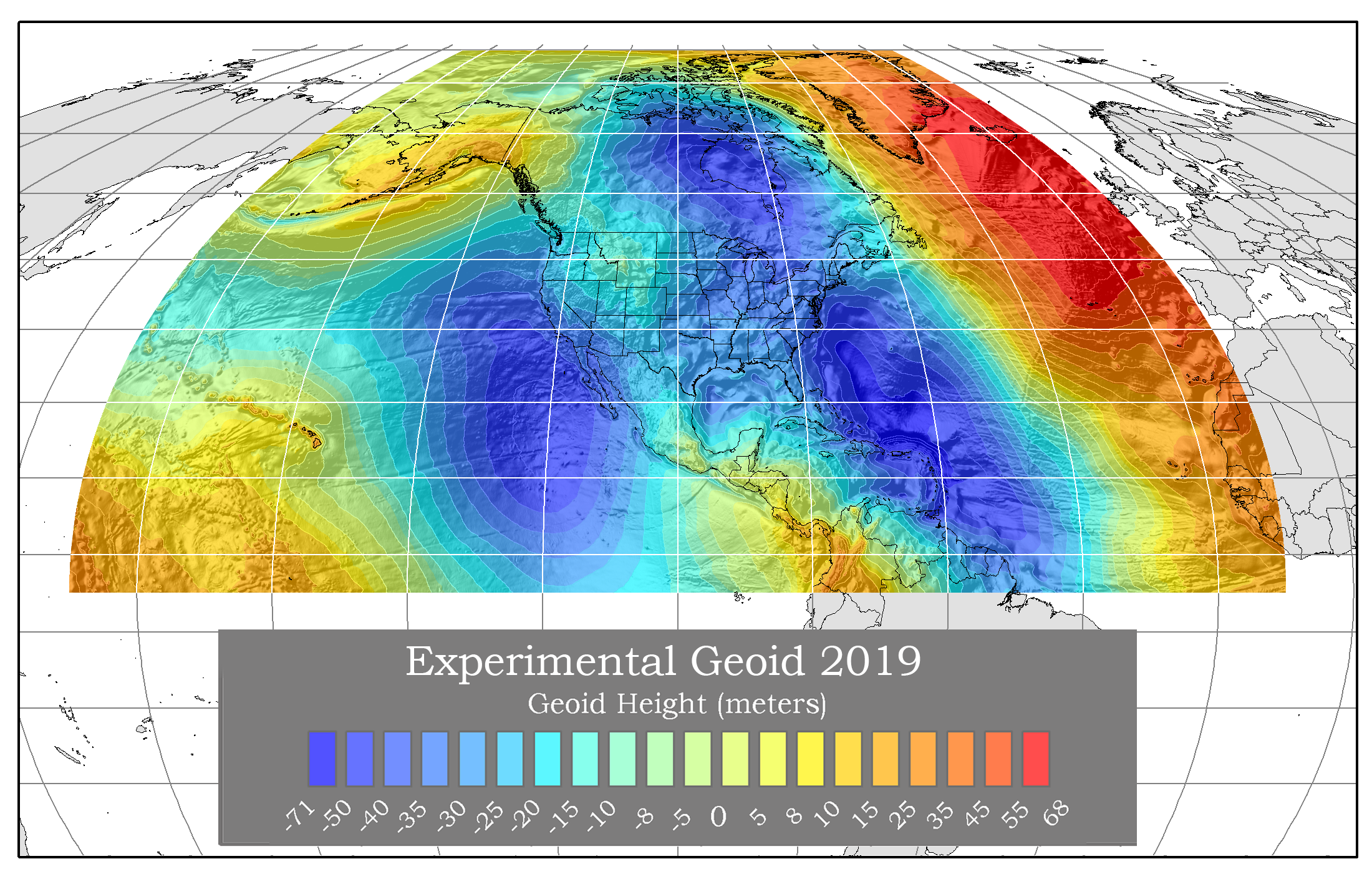
The term “geodetic” stems from the Greek words geo (Earth) and daiein (to divide), translating to “dividing the Earth.” Historically, this division referred to calculating distances and plotting maps. Today, geodetics involves far more complex processes, including precise measurements that account for the Earth’s irregular shape, known as the geoid.
The geoid isn’t perfectly spherical—it’s more like a slightly squished ball with dents and bulges caused by variations in Earth’s gravity. Why does this matter for GIS? Because all spatial data must align with this irregular surface to ensure accuracy, whether you’re mapping a coastline or designing a new highway.
How Geodetics Integrates with GIS
Geodetics provides the mathematical foundation for GIS. When you think of GIS, you probably imagine layers of colorful data on a map. But behind those visuals lies an intricate geodetic framework that ensures everything aligns properly. Here’s how it works:
- Geodetic Datums: These are reference points for positioning on Earth’s surface. They act as the backbone of GIS. For instance, the widely used WGS84 datum is the standard for GPS.
- Coordinate Systems: Geodetics ensures that the latitude and longitude data you use is consistent across platforms, whether you’re using a Geographic Coordinate System (like decimal degrees) or a Projected Coordinate System (like meters in the Universal Transverse Mercator, or UTM, system).
- Accurate Mapping: Without geodetics, your map layers wouldn’t “fit” together. Imagine plotting a road layer over a satellite image and realizing they’re completely misaligned—geodetics prevents such disasters.
Key Terminology in Geodetics
Before we dive deeper, let’s tackle some jargon. These terms often pop up in discussions about geodetics in GIS:
- Datums: The starting point for all spatial measurements. Think of it as the “zero” point on a map.
- Ellipsoids/Spheroids: Simplified 3D models of Earth, used for calculations. Ellipsoids are slightly flattened at the poles, while spheroids assume a more uniform shape.
- Geoid Models: The geoid represents Earth’s true shape, accounting for gravity variations. It’s used to correct elevation data.
- Coordinate Reference Systems (CRS): These systems define how spatial data corresponds to real-world locations. CRS ensures that everyone, from surveyors in Sweden to GIS analysts in Australia, speaks the same “spatial language.”
Here’s a relatable analogy: think of geodetics as the recipe book for baking a GIS cake. The datums, ellipsoids, and coordinate systems are the ingredients, and you need the right combination to make your map layers align perfectly. Without these geodetic principles, your cake (or map) would collapse!
Fun Fact: Early geodetic surveys relied on triangulation—using angles and distances to calculate positions. Today, we’ve upgraded to satellites, lasers, and high-precision GPS. Technology has taken geodetics from art to science!
Geodetics might sound complex, but its role is simple: it ensures your maps are accurate, reliable, and universally understood.

Geodetic Datums in GIS
At the heart of geodetics in GIS lies the concept of geodetic datums. If geodetics is the recipe book, datums are the foundation upon which every map is built. Without them, maps would be chaotic, like trying to assemble IKEA furniture without instructions—possible, but definitely not fun.
What Is a Geodetic Datum?
A geodetic datum is a mathematical model used to define the size and shape of Earth and to establish a reference point for locating positions on its surface. Think of it as a coordinate system’s anchor, ensuring that all spatial data has a consistent starting point.
There are two primary types of datums:
- Global Datums: These provide a universal reference for mapping the entire planet. They’re the go-to for applications like GPS, which needs to work seamlessly across continents.
- Local Datums: These are tailored to specific regions, optimized to improve accuracy in smaller areas. For instance, the North American Datum of 1983 (NAD83) is designed specifically for North America.
Commonly Used Geodetic Datums
Understanding datums used in GIS helps us appreciate how they ensure map accuracy. Here are some key players:
| Datum | Region/Use | Key Features |
|---|---|---|
| WGS84 | Global (used by GPS) | Provides a consistent, global reference. Widely adopted for navigation systems. |
| NAD83 | North America | Designed for higher accuracy in the U.S. and Canada. |
| ETRS89 | Europe | Aligns with the European tectonic plate, reducing distortions over the region. |
| GDA2020 | Australia | Accounts for continental drift, improving accuracy in Australia. |
Each datum is designed with a specific purpose, whether for global applicability or regional precision. For instance, WGS84, the standard for GPS, offers good accuracy worldwide, but NAD83 might outperform it in North America due to its local optimizations.
How to Choose the Right Datum for Your GIS Project
Selecting the correct datum is like choosing the right tool for a job—it ensures your results are accurate and meaningful. Here are a few tips for selecting the right datum:
- Consider the Scale of Your Project:
- For global projects (e.g., climate modeling or international shipping), use WGS84.
- For regional projects (e.g., urban planning in Europe), use a local datum like ETRS89.
- Understand Your Data Sources:
- If your data comes with a predefined datum, stick with it unless you’re prepared for the complexities of transforming data to a new datum.
- Be Mindful of Datum Transformations:
- Converting between datums introduces small errors. Tools like ArcGIS and QGIS offer transformation options, but these require careful handling.
- Account for Tectonic Movements:
- Some datums, like GDA2020, account for continental drift, which shifts locations by several centimeters annually. For high-precision applications, ignoring these shifts can lead to significant inaccuracies.
Case Study: The Transition from NAD27 to NAD83
In the mid-20th century, North America used NAD27 as its primary datum. However, as technology advanced, surveyors noticed discrepancies in maps created using NAD27. Enter NAD83, which used satellite data to improve accuracy and account for Earth’s shape more precisely. While the transition was costly and complex, it drastically improved mapping accuracy in the U.S. and Canada.
This case highlights why datums matter. Using an outdated or incorrect datum can lead to inaccuracies in GIS projects, potentially costing time, money, and trust.
The Importance of Geodetic Datums in GIS
A poorly chosen or outdated datum can wreak havoc on your spatial data. Imagine using a map layer in WGS84 and trying to overlay it with a NAD83 layer without adjusting for the differences—it would be like trying to match socks from different laundry baskets.
By grounding your GIS data in the right geodetic datum, you ensure consistency, accuracy, and reliability. In short, datums help you avoid a geographic mess.

The Role of Coordinate Systems in GIS
Geodetic datums set the stage, but coordinate systems are what bring the play to life. Without coordinate systems, we wouldn’t be able to translate Earth’s vast and complex surface into usable maps. In GIS, coordinate systems are the unsung heroes that let you turn raw data into actionable insights.
Types of Coordinate Systems
Coordinate systems in GIS fall into two broad categories: Geographic Coordinate Systems (GCS) and Projected Coordinate Systems (PCS). Each serves a unique purpose, and knowing when to use which can make or break your GIS project.
Geographic Coordinate Systems (GCS)
A Geographic Coordinate System uses a 3D spherical surface to define locations on Earth. It’s based on:
- Latitude: Horizontal lines (parallels) running east-west, measuring distances north or south of the equator.
- Longitude: Vertical lines (meridians) running from pole to pole, measuring distances east or west of the Prime Meridian.
The GCS is best for global-scale mapping where distortion isn’t a concern. Examples include:
- Identifying the coordinates of a city (e.g., Los Angeles: 34.0522° N, 118.2437° W).
- Global navigation systems (e.g., GPS).
Projected Coordinate Systems (PCS)
When you want to flatten the Earth’s surface onto a map (because spherical maps are hard to print!), you use a Projected Coordinate System. PCS transforms the 3D surface into a 2D plane using a projection method, like:
- Mercator Projection: Ideal for nautical navigation but distorts sizes near the poles.
- Universal Transverse Mercator (UTM): Divides the world into zones for precise, localized mapping.
- Lambert Conformal Conic: Commonly used for weather and aviation maps in mid-latitude regions.
The PCS is perfect for regional or local projects where accuracy and minimal distortion are key. For example, UTM is widely used for topographic maps.
Why Are Geodetic Coordinate Systems Important in GIS?
Using a coordinate system ensures that all spatial data aligns properly on your map. Without it, your GIS project would be like trying to piece together a puzzle with mismatched pieces. Here’s why geodetic coordinate systems are crucial:
- Spatial Accuracy:
Coordinate systems ensure that features like roads, rivers, and city boundaries appear exactly where they should. Misaligned systems can result in inaccurate analysis or faulty decision-making. - Data Interoperability:
Different datasets might use different coordinate systems. Properly understanding and managing these systems allows you to integrate data seamlessly, whether it’s from local government records or global satellite imagery. - Minimizing Distortion:
Every map projection introduces some distortion (distance, area, shape, or direction). Choosing the right coordinate system minimizes these issues for your specific use case.
Converting Between Coordinate Systems
Working with multiple datasets often means dealing with different coordinate systems. To ensure alignment, you’ll need to convert between systems. Here’s how:
- Identify the Current CRS:
Tools like ArcGIS and QGIS allow you to inspect the coordinate system of your data layers. - Select the Target CRS:
Choose the system best suited for your project. For instance, use UTM for regional projects and WGS84 for global datasets. - Transform the Data:
Modern GIS software automates much of the conversion process. However, watch out for transformation parameters, as incorrect settings can introduce errors.
A Real-Life Scenario: Why Coordinate Systems Matter
Imagine you’re a city planner tasked with overlaying a road network (in UTM) onto a satellite image (in WGS84). Without aligning the coordinate systems, the roads might appear to cut through buildings or float in rivers—not exactly the confidence-inspiring outcome your stakeholders expect! By using tools to align the coordinate systems, you ensure your data layers fit together perfectly.
GCS vs. PCS
| Feature | Geographic Coordinate System (GCS) | Projected Coordinate System (PCS) |
|---|---|---|
| Surface | 3D spherical | 2D flat |
| Units | Angular (degrees) | Linear (meters, feet, etc.) |
| Purpose | Global mapping | Regional or local mapping |
| Examples | Latitude/Longitude | UTM, Mercator, Lambert Conformal Conic |
Geodetic coordinate systems form the backbone of GIS by ensuring spatial data is both accurate and usable. But choosing the right system and managing transformations requires a careful balance between science and practicality.