Imagine trying to navigate without a reliable map or coordinate system in today’s interconnected world. It would feel like searching for a needle in a haystack—without even knowing if you’re in the right haystack! That’s where WGS84 geodetic coordinates step in, serving as the backbone for GPS systems, mapping applications, and countless technologies we use daily. But what exactly are WGS84 geodetic coordinates, and why are they so crucial?
WGS84, short for World Geodetic System 1984, is a standardized coordinate system that defines locations on Earth with pinpoint accuracy. It forms the geodetic framework used by GPS and numerous global positioning and mapping technologies. This global standard ensures that everyone—from a hiker using GPS to a space agency plotting satellite orbits—can work on the same “map.”
Let’s think of the Earth like a giant ball (not perfectly round, but close). Determining precise positions on this irregularly shaped ball is no small feat. WGS84 does this by combining mathematics, physics, and geodesy (the science of Earth’s shape, orientation, and gravitational field) to create a model of the planet that’s both consistent and practical for worldwide use.
Whether you’re an engineer, a geography enthusiast, or simply curious about how Google Maps works, understanding WGS84 gives you a fascinating insight into how we navigate and chart our world.

History and Development of WGS84
The story of WGS84 geodetic coordinates begins long before 1984, in humanity’s quest to understand and accurately map the Earth. Early cartographers and explorers grappled with the challenge of representing a three-dimensional world on flat maps, but as technology advanced, so did our need for precision. Enter the era of geodetic systems.
The Evolution of Geodetic Systems
Before WGS84, there were multiple local and regional coordinate systems, each tailored to a specific area. For instance, NAD27 was commonly used in North America, while European Datum 1950 served Europe. These systems worked well locally but failed to provide consistency on a global scale. Why? Because they were based on different reference ellipsoids and datums, which led to discrepancies when crossing borders or using global technologies.
By the mid-20th century, as global navigation and communication became more critical (thank you, space race!), the need for a universal geodetic system became undeniable. The United States Department of Defense spearheaded the creation of the World Geodetic System (WGS).
- WGS60 was the first iteration, developed in 1960, but it lacked precision.
- WGS66 followed, incorporating better data but still falling short of the accuracy needed for advanced applications.
- By WGS72, satellite data began playing a bigger role, leading to significant improvements.
However, it was WGS84, introduced in 1984, that became the global standard. Built on cutting-edge satellite data and modern computing, WGS84 remains the foundation of GPS and other geospatial technologies today.
Key Contributors to WGS84
- U.S. Department of Defense (DoD): The primary driver of WGS84 development to meet military navigation needs.
- National Geospatial-Intelligence Agency (NGA): Continuously updates WGS84 to ensure its relevance.
- Geodetic Scientists Worldwide: Collaboration with researchers has helped refine the system.
Why 1984?
No, it’s not a nod to George Orwell’s dystopian novel. By 1984, advancements in satellite technology and computing made it possible to develop a system with unprecedented global accuracy. It was designed as a unified geodetic reference for navigation, mapping, and Earth observation.
Fun Fact: The “World” in WGS
Unlike earlier systems that focused on specific regions, WGS84 covers the entire planet, from the highest peak of Mount Everest to the deepest point in the Mariana Trench. If you’re on Earth (or even just above it in space), WGS84 has got you mapped.
Continuous Updates to WGS84
Although WGS84 was officially introduced in 1984, it hasn’t been frozen in time. The system undergoes periodic updates to account for:
- Plate tectonics: Yes, continents are slowly drifting, and WGS84 adjusts to reflect these movements.
- Improved satellite technology: As satellites become more accurate, so does WGS84.
These updates ensure that WGS84 remains the most precise and reliable geodetic system available, even in 2025 and beyond.

Understanding the WGS84 System
To truly grasp the importance of WGS84 geodetic coordinates, it helps to break down what makes this system tick. At its core, WGS84 is a mathematical and geophysical model of the Earth, designed to define positions with extreme precision. But let’s demystify that—what does this mean in practical terms? How does it all work?
What Does WGS84 Stand For?
Let’s start with the basics:
- World: A system designed for global use, not limited to any specific region.
- Geodetic: Relating to the science of measuring Earth’s shape, gravity field, and orientation in space.
- System: A cohesive framework that combines data, models, and reference points.
- 1984: The year the system was formally adopted.
This isn’t just a name; it’s a mission statement for accuracy and universality.
The Shape of the Earth According to WGS84
You may have learned in school that Earth is a sphere. But that’s not entirely true. Earth is an oblate spheroid, meaning it’s slightly squished at the poles and bulges at the equator due to its rotation. WGS84 models this shape using an ellipsoid—a three-dimensional, oval-like figure that closely approximates the Earth’s true form.
WGS84 Ellipsoid Dimensions
Here’s where numbers come into play:
| Parameter | Value |
|---|---|
| Semi-major axis (a) | 6,378,137 meters |
| Flattening (f) | 1/298.257223563 |
| Semi-minor axis (b) | 6,356,752.314 meters |
These dimensions make WGS84 one of the most precise representations of Earth’s shape ever created.
Reference Frames and the Geoid Model
- Reference Frame:
WGS84 uses a Cartesian coordinate system to define positions relative to Earth’s center of mass. Think of this as a giant 3D grid stretching across the planet. The origin point? Right at Earth’s core. This makes WGS84 a geocentric system—perfect for global applications. - Geoid Model:
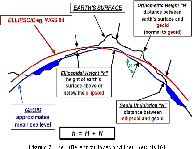
While the ellipsoid defines the general shape of the Earth, the geoid accounts for variations caused by gravity. Picture the geoid as an imaginary sea level that wraps around the Earth, fluctuating due to gravitational forces. This allows WGS84 to adjust for real-world irregularities.
Components of the WGS84 System
To put it all together, WGS84 includes:
- A Mathematical Ellipsoid: Defines the Earth’s overall shape.
- A Reference Frame: A coordinate system centered on the Earth’s center of mass.
- A Geoid Model: Adjusts for gravitational anomalies to improve accuracy.
This combination ensures that WGS84 is not only accurate but also adaptable to a variety of applications—from mapping mountain peaks to guiding autonomous drones.
Geocentric vs. Geodetic Coordinates
If you’ve ever wondered whether there’s a difference between geocentric and geodetic coordinates, here’s the scoop:
- Geocentric coordinates are based on the Earth’s center and are expressed in three dimensions (X, Y, Z).
- Geodetic coordinates use latitude, longitude, and altitude, measured relative to the WGS84 ellipsoid.
Both systems work together within WGS84 to provide a complete picture of any location on Earth.
Why WGS84 Works So Well
- Global Compatibility: It’s used worldwide, making it ideal for international applications.
- High Accuracy: Thanks to satellite data, it achieves sub-meter precision in most scenarios.
- Flexibility: Whether you’re charting a flight path or tracking tectonic movements, WGS84 has you covered.
WGS84 combines mathematical brilliance and geophysical insights to provide the most reliable coordinate system ever developed. It’s the invisible thread tying our digital maps, GPS systems, and geographic applications together.

How WGS84 Geodetic Coordinates Work
At first glance, the workings of WGS84 geodetic coordinates might seem like magic. After all, how does a system allow us to pinpoint a location anywhere on Earth with astounding precision? The answer lies in a clever combination of mathematics, satellite technology, and geodetic principles.
Let’s break it down step by step to understand how WGS84 operates and why it’s so effective.
The Coordinate System: Latitude, Longitude, and Altitude
WGS84 defines any location on Earth using three fundamental components:
- Latitude (ϕ):
- Measures how far north or south a point is from the Equator.
- Values range from -90° (South Pole) to +90° (North Pole).
- Longitude (λ):
- Indicates how far east or west a point is from the Prime Meridian (which passes through Greenwich, UK).
- Values range from -180° (west) to +180° (east).
- Altitude (h):
- Refers to a point’s height above (or depth below) the WGS84 ellipsoid.
- Measured in meters and crucial for applications like aviation and surveying.
When combined, these coordinates form a unique “address” for every location on Earth.
Geocentric Cartesian Coordinates
While latitude, longitude, and altitude are intuitive, WGS84 also uses a geocentric Cartesian system for advanced calculations. Here’s how it works:
- X, Y, and Z coordinates define a position relative to Earth’s center of mass.
- This system is especially useful for satellite-based technologies, where positions are calculated in a 3D grid.
Imagine a GPS satellite measuring its distance to your phone using signals. The WGS84 Cartesian system ensures that the satellite knows exactly where you are, even in 3D space.
How WGS84 Determines Locations
The process of determining precise locations involves several steps:
- Satellite Data Collection:
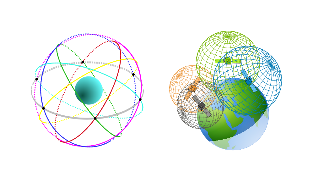
- GPS satellites orbit Earth while broadcasting signals with their location and time.
- A GPS receiver (e.g., your smartphone) picks up signals from multiple satellites.
- Triangulation:
- The receiver calculates its distance from each satellite based on how long the signals take to arrive.
- Using signals from at least four satellites, the receiver determines its position in WGS84 coordinates.
- Conversion to Geodetic Coordinates:
- The receiver converts its geocentric (X, Y, Z) position into geodetic coordinates (latitude, longitude, altitude).
This combination of satellite data and mathematical models makes WGS84 incredibly accurate.
Practical Example: A Day in the Life of WGS84
Let’s say you’re navigating to your favorite coffee shop using GPS. Here’s how WGS84 is quietly working in the background:
- Your phone’s GPS receiver determines its current location in WGS84 coordinates.
- The app cross-references this data with a map database (also based on WGS84).
- Turn-by-turn directions guide you, ensuring every step aligns perfectly with the real-world streets.
Without WGS84, even a short trip to the coffee shop could leave you lost and frustrated. ☕
Advantages of the WGS84 System
WGS84 stands out as the preferred coordinate system for several reasons:
- Global Consistency: The same system works seamlessly across countries and continents.
- High Precision: Sub-meter accuracy ensures reliability in critical applications like aviation.
- Satellite Integration: Designed to work flawlessly with GPS, Galileo, and other satellite constellations.
- Flexibility: Adapts to diverse use cases, from mapping city infrastructure to studying climate change.
Challenges and Limitations
While WGS84 is a marvel of engineering, it’s not perfect:
- Gravitational Variations: The ellipsoid model simplifies Earth’s shape, which varies slightly due to gravity.
- Periodic Updates Required: Tectonic shifts and advancements in technology necessitate regular updates.
- Dependence on Satellites: Without satellite signals, WGS84-based systems can’t function.
Despite these challenges, WGS84 remains unmatched in its versatility and accuracy.